
Anúncios
Understanding how to measure land accurately is essential for property owners, real estate professionals, farmers, and construction planners seeking precise boundary and area calculations.


Whether you’re planning to buy property, fence your yard, develop agricultural land, or simply need to know the exact dimensions of your terrain, mastering land measurement techniques can save you time, money, and potential legal disputes. The good news is that technology has made this task significantly easier than ever before.
From traditional surveying methods to modern GPS applications, there are multiple approaches to measuring land with varying degrees of accuracy and complexity. This comprehensive guide explores the most effective techniques, tools, and best practices for measuring terrain in different situations and contexts.
📏 Why Accurate Land Measurement Matters
Precise land measurement serves multiple critical purposes that extend far beyond simple curiosity about property size. Understanding your terrain’s exact dimensions impacts legal documentation, financial transactions, and practical planning decisions.
Property transactions depend heavily on accurate measurements. When buying or selling land, the price directly correlates with the area being transferred. Even small measurement errors can translate to significant financial discrepancies, potentially costing thousands of dollars or creating grounds for legal disputes.
Agricultural planning requires detailed knowledge of field dimensions. Farmers need precise measurements to calculate seed quantities, fertilizer applications, irrigation coverage, and crop yield estimates. Without accurate terrain data, resource allocation becomes inefficient and costly.
Construction and development projects cannot proceed without reliable land surveys. Building permits, zoning compliance, foundation planning, and utility installations all require documented measurements that meet regulatory standards and engineering specifications.
🗺️ Traditional Methods for Measuring Terrain
Before digital technology revolutionized surveying, professionals relied on time-tested techniques that remain relevant today, especially for official documentation and legal purposes.
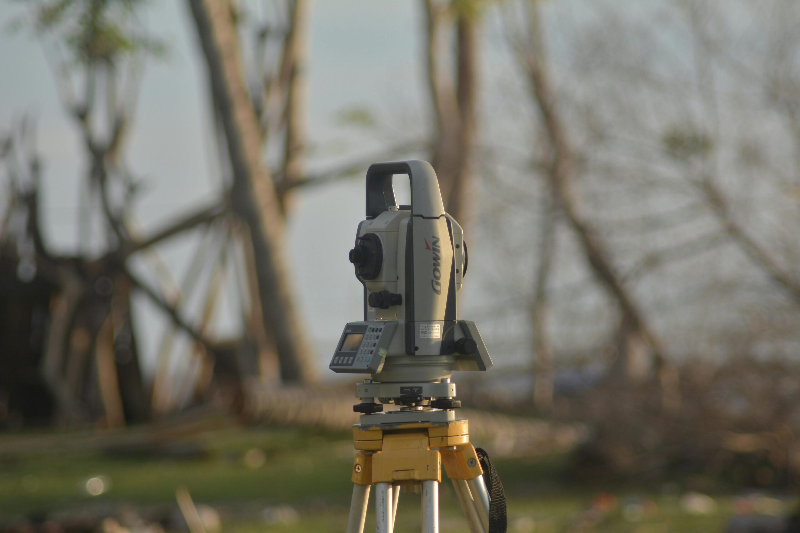
Professional Land Surveying
Licensed surveyors use sophisticated equipment including total stations, theodolites, and GPS receivers to establish precise property boundaries and calculate areas with exceptional accuracy. This method provides legally defensible measurements suitable for property deeds, boundary disputes, and official records.
Professional surveys typically cost between $300 and $1,000 or more, depending on property size, terrain complexity, and local regulations. While expensive, this investment proves invaluable for significant transactions or legal situations.
Measuring Tape and Geometric Calculations
For smaller properties or preliminary estimates, basic measuring tapes combined with geometric formulas offer a practical approach. This method works best for regularly shaped plots where you can identify clear boundaries and measure straight lines between corners.
For rectangular properties, simply multiply length by width. Triangular areas require the formula: (base × height) ÷ 2. Irregular shapes demand subdivision into manageable geometric sections, calculated separately and then summed together.
Wheel Measurement Tools
Surveyor’s wheels or measuring wheels provide a middle ground between tape measures and professional equipment. These rolling devices count rotations as you walk the perimeter, calculating distances automatically. They work well for larger properties where tape measures become impractical.
📱 Modern GPS Technology for Land Measurement
Smartphone applications have democratized land measurement, putting powerful surveying capabilities directly into property owners’ hands. GPS-based measurement apps offer remarkable convenience and surprisingly accurate results for most practical purposes.
These applications use satellite positioning to track your movement around property boundaries. As you walk the perimeter with your smartphone, the app records GPS coordinates at regular intervals, creating a digital outline of your terrain. Advanced algorithms then calculate the enclosed area automatically.
GPS land measurement apps typically achieve accuracy within 1-3 meters under good conditions, making them suitable for agricultural planning, fencing estimates, landscaping projects, and preliminary property assessments. While not sufficiently precise for legal surveys, they excel at providing quick, reliable measurements for everyday applications.

Advantages of GPS Measurement Applications
Mobile apps designed for terrain measurement deliver numerous benefits that make them increasingly popular among property owners, farmers, and outdoor professionals:
- Instant accessibility: No need to schedule appointments or wait for professional surveyors
- Cost-effective: Many apps are free or cost significantly less than traditional surveys
- Multiple measurement units: Switch easily between acres, hectares, square meters, or square feet
- Historical tracking: Save multiple properties and measurements for future reference
- Perimeter calculation: Automatically determine fencing or boundary lengths alongside area
- Map integration: Visualize measurements overlaid on satellite imagery
- Export capabilities: Share measurement data via email or save to cloud storage
🌾 Measuring Agricultural Land and Fields
Farmers and agricultural professionals face unique measurement challenges due to irregular field shapes, varied terrain, and practical accessibility issues. Accurate field measurement directly impacts profitability through optimized resource allocation.
Traditional walking methods work well for most agricultural applications. Using a GPS measurement app, walk along field boundaries at a steady pace, ensuring your device maintains clear satellite reception. For best results, perform measurements during clear weather conditions when GPS accuracy peaks.
Large or complex fields benefit from subdivision strategies. Break extensive properties into manageable sections, measure each separately, then combine the results. This approach reduces GPS drift errors and provides detailed information about different zones within the same property.
Practical Tips for Farm Field Measurement
Achieving reliable agricultural land measurements requires attention to several practical considerations that affect accuracy and usefulness:
- Measure during dry conditions when you can access all field areas easily
- Walk close to actual boundaries rather than cutting corners across uneven terrain
- Account for obstacles like trees, buildings, or water features in your path
- Remeasure critical fields periodically to verify consistency
- Document measurements with photos and notes about landmarks
- Consider seasonal variations that might affect accessible boundaries
🏘️ Residential Property Measurement Techniques
Homeowners frequently need property measurements for fencing projects, landscaping plans, addition permits, or simple curiosity about lot size. Residential measurement often balances accuracy requirements against budget constraints.
For precise legal documentation, hire a professional surveyor who will establish official boundary markers and provide certified measurements. This investment proves essential when resolving boundary disputes with neighbors or securing building permits for additions that approach setback limits.
For planning purposes, GPS apps or careful tape measurements usually suffice. When installing a fence, laying sod, or designing a garden, accuracy within a few feet typically meets practical needs without requiring expensive professional services.
Common Residential Measurement Scenarios
Different home improvement projects demand varying accuracy levels. Understanding these requirements helps you choose the appropriate measurement method:
| Project Type | Required Accuracy | Recommended Method |
|---|---|---|
| Property sale/purchase | Legal precision | Professional surveyor |
| Fence installation | 1-2 feet | GPS app or tape measure |
| Landscaping design | 2-3 feet | GPS app |
| Building permit | Legal precision | Professional surveyor |
| Lawn care planning | 5-10 feet | GPS app |
🛠️ Essential Tools for DIY Land Measurement
Equipping yourself with the right measurement tools ensures better results regardless of which method you choose. Building a basic measurement toolkit doesn’t require significant investment but dramatically improves accuracy and efficiency.
A quality measuring tape remains indispensable for smaller properties and verification measurements. Choose a model at least 100 feet long with clear markings and a durable case that locks securely to prevent retraction errors.
Boundary markers help establish clear reference points during measurement. Simple wooden stakes, flags, or even temporary spray paint allow you to mark corners and create visible guidelines as you work through complex property shapes.
A smartphone with GPS capability and a dedicated measurement app forms the cornerstone of modern DIY surveying. Ensure your device has a clear view of the sky for optimal satellite reception, and consider an external battery pack for extended measurement sessions.
🎯 Improving Measurement Accuracy
Whether using professional equipment or smartphone apps, specific techniques and considerations significantly impact the reliability of your terrain measurements.
GPS Accuracy Enhancement Strategies
GPS-based measurements achieve best results under optimal conditions. Environmental factors, device settings, and technique all influence final accuracy:
- Choose clear days: Cloud cover, storms, and heavy foliage reduce GPS signal quality
- Avoid tall structures: Buildings, cliffs, and dense tree canopies block satellite signals
- Walk steadily: Maintain consistent speed around boundaries rather than stopping and starting
- Allow GPS lock: Wait for your device to establish strong satellite connections before starting
- Enable high accuracy mode: Most apps offer settings that prioritize precision over battery life
- Take multiple measurements: Repeat important surveys and average results for better reliability
Common Measurement Errors to Avoid
Understanding typical mistakes helps prevent inaccurate results that could lead to planning problems or financial miscalculations:
Slope neglect represents a frequent error, especially on hillside properties. GPS and maps measure horizontal distance, but sloped terrain has greater actual surface area. For steep properties, professional surveying becomes important for accurate calculations.
Boundary confusion causes problems when property lines aren’t clearly marked. Never assume fence lines, tree rows, or mowed edges represent legal boundaries without verification through property deeds or professional surveys.
Unit conversion mistakes create dramatic errors. Always double-check whether measurements display in square feet, acres, square meters, or hectares, and verify conversions using reliable references before making decisions based on calculated areas.
💰 Understanding Measurement Costs and Value
Different measurement approaches involve varying expenses, from free DIY options to professional services costing hundreds or thousands of dollars. Choosing appropriately balances accuracy requirements against budget realities.
Professional land surveys typically range from $300 for simple residential lots to several thousand dollars for large, complex, or heavily wooded properties. This investment provides legally defensible measurements, official documentation, and permanent boundary markers.
GPS measurement applications cost nothing to under $50 for premium versions with advanced features. This minimal expense delivers remarkable value for agricultural management, preliminary planning, and general property knowledge.
Traditional DIY methods using measuring tapes and geometric calculations cost only the price of basic tools—usually under $50 total. While time-consuming for large properties, this approach works perfectly for small, regularly shaped lots.
📊 Converting and Interpreting Measurement Results
Raw measurement data becomes useful only when properly converted and understood in relevant units and contexts. Different applications and regions use various measurement standards, requiring comfortable navigation between systems.
Common Area Measurement Conversions
Understanding relationships between different measurement units prevents confusion and enables clear communication:
- 1 acre = 43,560 square feet = 4,047 square meters = 0.405 hectares
- 1 hectare = 10,000 square meters = 2.471 acres
- 1 square kilometer = 100 hectares = 247.1 acres
- 1 square mile = 640 acres = 259 hectares
Agricultural contexts typically reference acres or hectares, while construction and landscaping often use square feet or square meters. Real estate listings vary by region, with North America favoring acres and square footage, while international markets prefer hectares and square meters.
🌍 Legal Considerations for Property Measurement
While GPS apps and DIY methods provide valuable information for planning purposes, they don’t replace official surveys for legal situations. Understanding when professional documentation becomes necessary protects you from potential complications.
Property transactions requiring title insurance, mortgage financing, or boundary verification need professional surveys performed by licensed surveyors. These official measurements become part of legal records and carry professional liability guarantees.
Boundary disputes with neighbors demand certified surveys that courts recognize as authoritative evidence. DIY measurements, regardless of accuracy, lack legal standing in formal proceedings and won’t resolve contested property lines.
Building permits and zoning compliance often require professional survey documentation showing setback distances, easements, and precise property dimensions. Municipalities typically won’t accept app-based measurements for official permits.
🚀 Maximizing the Value of Your Measurements
Once you’ve accurately measured your terrain, that data becomes valuable for numerous planning, financial, and management applications beyond the initial measurement purpose.
Document and archive your measurements with clear labels, dates, and reference photos. Digital records stored in cloud services ensure you won’t lose important property information and can easily share data with contractors, real estate agents, or family members.
Create visual representations by overlaying measurements on satellite imagery or property maps. This combination of spatial data and measurement information provides intuitive understanding that raw numbers alone cannot convey.
Update measurements periodically, especially for agricultural land where boundary maintenance, erosion, or clearing activities might alter usable area over time. Regular remeasurement creates historical records showing property changes and validates earlier calculations.
✨ Choosing the Right Measurement Approach for Your Needs
No single measurement method serves all purposes equally well. Selecting the optimal approach depends on accuracy requirements, budget constraints, property characteristics, and intended use of the measurement data.
For legal documentation, property transactions, or boundary disputes, professional surveying remains irreplaceable despite higher costs. The investment provides peace of mind, legal protection, and official documentation that informal measurements cannot match.
Agricultural management, fencing projects, and landscaping plans benefit tremendously from GPS measurement apps that deliver quick, sufficiently accurate results at minimal cost. These tools empower property owners with immediate access to measurement capabilities previously requiring professional assistance.
Small residential properties with regular shapes might need only simple tape measures and basic calculations for many practical purposes. This approach costs virtually nothing and provides adequate accuracy for informal planning and estimation.
The key lies in matching your measurement method to your specific situation, balancing precision requirements against available resources while understanding the limitations and appropriate applications of each technique. Modern technology has made terrain measurement more accessible than ever, putting powerful tools directly into property owners’ hands for everyday applications while professional services remain available when legal precision becomes necessary.