
Anúncios
Measuring land accurately is essential for property owners, builders, farmers, and real estate professionals who need precise data for planning, legal documentation, and development projects.


Whether you’re dividing property, calculating acreage for agricultural purposes, or verifying boundaries before a purchase, understanding how to measure land correctly can save time, money, and potential legal disputes. The process has evolved significantly over the years, transitioning from traditional methods involving chains and compasses to modern GPS technology and smartphone applications.
Today’s landowners have access to various tools and techniques that make terrain measurement more accessible than ever before. From professional surveying equipment to user-friendly mobile apps, the options cater to different levels of precision, budget, and technical expertise. Let’s explore the comprehensive world of land measurement and discover which methods work best for your specific needs. 📐
Understanding the Basics of Land Measurement
Land measurement involves calculating the area, perimeter, and boundaries of a piece of property. The fundamental principle remains consistent across all methods: establishing reference points and calculating the distances between them to determine total area. However, the tools and techniques used can vary dramatically based on accuracy requirements and property characteristics.
Traditional units of measurement include acres, hectares, square feet, and square meters. In the United States, acres remain the standard for large properties, while square feet is common for residential lots. Internationally, the metric system using hectares and square meters dominates. Understanding these units and their conversions is crucial for anyone involved in land measurement activities.
Common Units and Their Conversions
Before diving into measurement methods, familiarizing yourself with standard land measurement units helps ensure accurate calculations and clear communication with professionals, buyers, or sellers.
- 1 acre equals 43,560 square feet or approximately 4,047 square meters
- 1 hectare equals 10,000 square meters or about 2.47 acres
- 1 square mile contains 640 acres
- 1 square yard equals 9 square feet
- 1 square meter equals approximately 10.76 square feet
Traditional Methods for Measuring Terrain
Long before digital technology revolutionized land surveying, professionals relied on manual tools and mathematical principles to measure properties with impressive accuracy. These traditional methods still hold value today, particularly in situations where technology may be unavailable or as verification tools alongside modern techniques.
The Chain and Compass Technique
Surveyors historically used measuring chains (typically 66 feet long) combined with magnetic compasses to map property boundaries. This method involves walking the perimeter while recording distances and angles at each corner. Though labor-intensive, chain surveying established many of the property boundaries still recognized legally today. The technique requires at least two people and works best on relatively flat terrain with clear sight lines between boundary markers.
Using a Measuring Wheel
The measuring wheel, also known as a surveyor’s wheel, offers a simple mechanical solution for determining distances. As you walk along a property line, the wheel counts rotations and calculates linear distance. For rectangular or square plots, you can measure each side and multiply length by width to determine area. This method provides reasonable accuracy for informal measurements but lacks the precision needed for legal documentation. 🎯
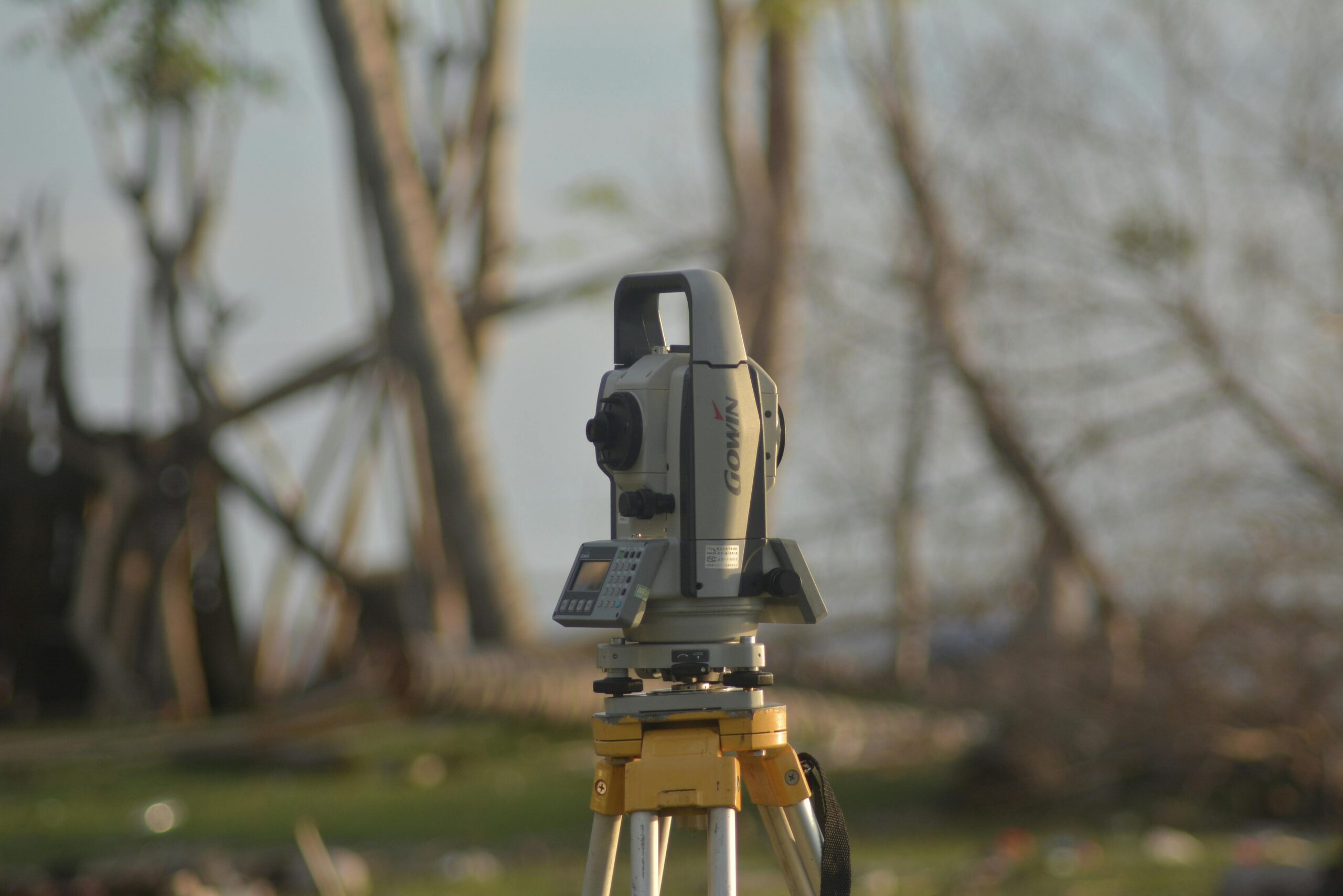
Professional Land Surveying Services
When legal accuracy is paramount—such as for property transactions, boundary disputes, or construction projects—hiring a licensed land surveyor becomes essential. Professional surveyors bring expertise, specialized equipment, and legal authority that ensures measurements meet regulatory standards and hold up in court if necessary.
Licensed surveyors use advanced instruments including total stations, theodolites, and GPS receivers that can measure distances, angles, and elevations with centimeter-level precision. They also research historical property records, deeds, and previous surveys to establish accurate boundaries that align with legal descriptions. The investment in professional surveying typically ranges from several hundred to several thousand dollars depending on property size, terrain complexity, and local market rates.
When Professional Surveying is Necessary
Certain situations legally require professional surveying services, while others strongly benefit from the accuracy and documentation these experts provide:
- Property purchases and sales requiring title insurance
- Subdivision of land into multiple parcels
- Boundary disputes with neighbors
- Construction projects requiring building permits
- Easement establishment or verification
- Flood zone determinations
- Topographic mapping for development planning

Modern GPS Technology for Land Measurement
Global Positioning System technology has transformed land measurement from a specialized professional service into something accessible to everyday property owners. GPS-enabled devices and smartphones can determine location coordinates with remarkable accuracy, making property measurement faster and more affordable than ever before.
Consumer-grade GPS devices typically offer accuracy within 3-5 meters under optimal conditions, which suffices for agricultural planning, rough property estimates, and recreational purposes. Professional-grade GPS receivers with differential correction capabilities can achieve centimeter-level accuracy, rivaling traditional surveying methods at a fraction of the time and cost.
How GPS Land Measurement Works
GPS measurement applications work by recording coordinate points as you walk the property perimeter. The device captures latitude and longitude at each corner or at regular intervals, then calculates the enclosed area using geometric formulas. Most applications automatically handle the complex mathematics, displaying results in your preferred units instantly.
For best results, walk slowly around the property boundary with your device held steadily. Clear sky visibility improves accuracy, as GPS signals can be degraded by tree cover, buildings, or atmospheric conditions. Taking multiple measurements and averaging the results helps compensate for minor GPS fluctuations and improves overall reliability.
Smartphone Apps for Measuring Land Areas
The proliferation of smartphones with built-in GPS capabilities has spawned numerous applications specifically designed for land measurement. These apps democratize access to property measurement tools that once required expensive equipment and specialized training. 📱
Quality land measurement apps offer intuitive interfaces where you can simply walk your property boundaries while the app automatically records your path. Many include features like satellite imagery overlay, perimeter calculation, distance measurement between points, and the ability to save multiple properties for future reference. The best applications also allow for manual point placement on maps for properties you cannot physically walk.
Key Features to Look for in Measurement Apps
When selecting a land measurement application, consider these important capabilities that enhance usability and accuracy:
- Multiple unit options (acres, hectares, square meters, square feet)
- Satellite or hybrid map views for visual confirmation
- Manual point placement for inaccessible properties
- Export capabilities for sharing measurements
- Offline functionality for areas without cellular coverage
- Perimeter and distance calculations
- Coordinate display and recording
- Multiple property storage and organization
Measuring Irregular Shaped Properties
While rectangular properties allow for simple length-times-width calculations, many parcels feature irregular boundaries that follow natural features like streams, ridgelines, or historical property divisions. Measuring these properties requires more sophisticated approaches that account for curves, angles, and complex geometries.
GPS-based methods excel with irregular properties because they simply record the actual boundary path without requiring geometric assumptions. As you walk the perimeter, the device captures the true shape, including all curves and angles. The software then divides this irregular polygon into triangles or other calculable shapes to determine total area—all happening automatically behind the scenes.
Breaking Down Complex Shapes
For manual calculations of irregular properties, surveyors traditionally divide the parcel into simpler geometric shapes—triangles, rectangles, and trapezoids—that can be individually calculated and summed. This technique works well when you have accurate measurements of key distances and angles but requires solid geometry knowledge and careful attention to detail to avoid errors.
Accounting for Slopes and Elevation Changes
Flat land measurement differs significantly from properties with hills, valleys, or mountainous terrain. A property that appears to be 10 acres when measured on a two-dimensional map might actually contain 12 or more acres when the additional surface area created by slopes is considered. ⛰️
This distinction matters particularly for agricultural purposes, where actual plantable area depends on surface area rather than horizontal projection. Construction projects also need accurate slope measurements for earthwork calculations, drainage planning, and foundation design. Professional surveyors use specialized instruments to measure both horizontal distances and vertical elevations, creating topographic maps that reveal the three-dimensional character of the property.
Some advanced GPS applications and handheld devices include altimeters that record elevation changes, allowing for slope-adjusted area calculations. However, accuracy in vertical measurements typically lags behind horizontal precision, so critical applications still benefit from professional surveying with dedicated elevation measurement tools.
Legal Considerations in Property Measurement
Understanding the legal aspects of property measurement helps avoid disputes and ensures your measurements hold appropriate weight for their intended purpose. Legal property descriptions in deeds often reference historical surveys, monuments, and boundary markers that may not align perfectly with GPS coordinates or physical features visible today.
Property boundaries established by legal surveys take precedence over measurements you might make yourself, even if your modern GPS suggests a different location. Many jurisdictions recognize the principle of “senior rights,” meaning older, established boundaries generally prevail over newer measurements when discrepancies arise. This legal framework protects property owners from having boundaries constantly redrawn as measurement technology improves.
Understanding Boundary Markers and Monuments
Professional surveys establish permanent markers—called monuments—at property corners. These might include iron pins, concrete markers, stone monuments, or even natural features like specific trees or rock formations. When measuring your property, locating these existing monuments provides the most legally defensible boundary references.
Never remove or alter survey monuments, as doing so may constitute a crime in many jurisdictions. If you cannot locate markers mentioned in your deed, a professional surveyor can often find them using metal detectors and historical records, or establish new monuments that align with the legal description.
Practical Tips for Accurate DIY Measurements
Whether you’re using a smartphone app, handheld GPS device, or traditional measuring tools, following best practices significantly improves measurement accuracy and reliability:
- Perform measurements during optimal conditions—clear weather with good satellite visibility
- Walk slowly and steadily around boundaries, holding your device at a consistent height
- Take multiple measurements and compare results to identify outliers
- Mark corners clearly before measuring to ensure you follow the actual boundary
- Allow GPS devices adequate time to acquire satellite signals before starting
- Document your measurements with photos and notes for future reference
- Cross-reference with property maps or satellite imagery when possible
- Understand your tool’s accuracy limitations and use appropriate methods for critical applications
Agricultural Applications of Land Measurement
Farmers and agricultural professionals rely heavily on accurate land measurement for crop planning, yield estimation, irrigation design, and regulatory compliance. Knowing precise field acreage allows for accurate seed, fertilizer, and pesticide application rates, optimizing costs while minimizing environmental impact. 🌾
Modern precision agriculture integrates GPS measurement with yield monitoring, variable rate application systems, and field mapping software. Farmers can measure fields quickly with mobile apps or dedicated agricultural GPS units, then use those measurements to program equipment, plan crop rotations, and document conservation practices for subsidy programs that require detailed acreage reporting.
Field Mapping for Farm Management
Beyond simple acreage calculation, comprehensive field mapping identifies variations within parcels—soil types, drainage patterns, elevation changes—that affect crop performance. GPS-based measurement tools allow farmers to create detailed field boundaries that integrate with farm management software, enabling data-driven decisions that improve productivity and profitability.
Real Estate and Property Development Uses
Real estate professionals, developers, and investors frequently need quick property measurements for preliminary assessments, market analysis, and feasibility studies. While formal surveys remain necessary for transactions and development approvals, preliminary measurements help identify opportunities and evaluate potential before investing in professional services.
Mobile measurement apps enable real estate agents to verify property sizes claimed in listings, help buyers understand exactly what they’re purchasing, and identify discrepancies that might require investigation. Developers use preliminary measurements to estimate development capacity, calculate density allowances, and determine if properties meet minimum size requirements for intended uses.
Choosing the Right Measurement Method for Your Needs
Selecting the appropriate land measurement approach depends on your specific requirements, accuracy needs, budget, and intended use of the results. A simple estimation for personal curiosity requires different tools than a legal boundary determination for a property transaction.
| Purpose | Recommended Method | Typical Accuracy |
|---|---|---|
| General estimation | Smartphone GPS app | ±3-5 meters |
| Agricultural planning | Handheld GPS or app | ±2-5 meters |
| Property transactions | Professional survey | ±0.01-0.1 meters |
| Boundary disputes | Licensed surveyor | ±0.01-0.05 meters |
| Construction projects | Professional survey | ±0.01-0.1 meters |
| Recreational purposes | Smartphone app | ±3-10 meters |
Cost Considerations Across Different Methods
Budget naturally influences which measurement method you choose. Smartphone apps typically cost nothing to $20, offering remarkable value for informal measurements and planning purposes. Handheld GPS units range from $100 for basic consumer models to $500+ for agricultural-grade devices with enhanced accuracy and features.
Professional surveying represents the most significant investment, generally starting around $300-500 for simple residential lots and increasing based on property size, terrain complexity, research requirements, and local market rates. Large or complex properties can easily require $2,000-5,000 or more in surveying costs. However, this investment provides legally defensible measurements, professional liability coverage, and documentation that protects property rights and facilitates transactions.
Enhancing Accuracy with Technology Combinations
The most effective measurement strategies often combine multiple approaches, using technology to complement traditional methods and verify results. For example, you might use a smartphone app to make initial measurements, then verify key dimensions with a measuring tape or laser rangefinder for important corners or boundaries. 🔍
Cross-referencing GPS measurements with satellite imagery helps identify potential errors—if your measured boundary cuts through a building visible on satellite photos, something is obviously wrong. Comparing your measurements with property dimensions listed in deed records or tax assessments provides another validation checkpoint before making important decisions based on your results.
Future Trends in Land Measurement Technology
Land measurement technology continues evolving rapidly, with emerging tools promising even greater accessibility and accuracy. Drone-based photogrammetry allows for detailed property mapping from aerial imagery, creating three-dimensional models that reveal topography, vegetation, and structures. These systems can measure properties that are difficult or impossible to walk while providing visual documentation of current conditions.
Improved GPS satellite constellations, including Europe’s Galileo and China’s BeiDou systems, supplement the original American GPS network with additional satellites that improve accuracy and reliability worldwide. Smartphone GPS capabilities continue advancing, with newer devices incorporating multiple satellite systems and sophisticated signal processing that narrows the accuracy gap between consumer and professional equipment.
Augmented reality applications represent another frontier, potentially allowing users to visualize property boundaries, easements, and zoning restrictions overlaid on the actual landscape through their phone cameras. As these technologies mature and become mainstream, accurate land measurement will become increasingly accessible to everyone who needs it.
Understanding how to measure land accurately empowers property owners, farmers, developers, and real estate professionals with essential information for informed decision-making. Whether you choose a simple smartphone app for quick estimates or invest in professional surveying for legal certainty, knowing your options and their appropriate applications ensures you get the accuracy you need at a cost you can justify. With modern tools making land measurement more accessible than ever, there’s no reason to remain uncertain about property dimensions that affect value, usability, and rights. 🎯